River Map or Watershed Map: Two Views of Water
A river map or watershed map answers different questions: learn which view traces channels, which shows drainage areas, and how to read them together.
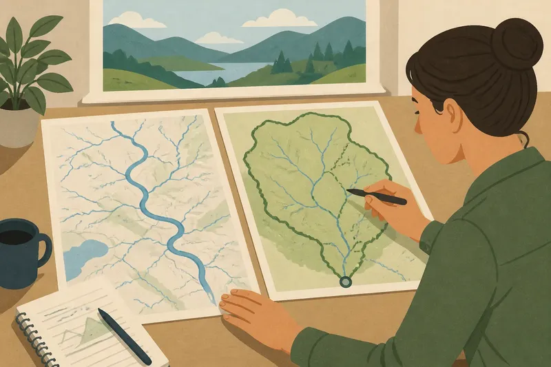
A river map or watershed map can show the same place and still answer different questions. A river map traces watercourses—the visible or mapped channels; a watershed map outlines the land that drains toward a selected outlet. Confusing those jobs can make a stream seem to stop at a boundary or make a drainage area look like a river’s course.
Choose the view that matches the question in front of you. If you need to follow a channel through a region, start with a river map. If you need to understand which slopes and tributaries contribute water to a particular stream, begin with a watershed map.
A river map draws the channel network
River maps emphasize lines: major rivers, smaller tributaries, and sometimes canals, lakes, or named streams. Their purpose is to show where mapped waterways run and how they connect. Depending on the map’s scale and source, a small drainage may be omitted, simplified, or shown only in part.
That makes a river map useful for tracing a route along a watercourse, locating a confluence, or comparing the arrangement of tributaries. It does not, by itself, show all the land that sheds water into those channels. A blue line tells you where the map represents a channel, not the full extent of its contributing area.
Pay attention to what the map calls a river, stream, creek, or channel. Those labels may reflect local naming, mapping conventions, or the map’s level of detail. A waterway can also change name along its course, so follow the connected line rather than assuming that a label marks the entire drainage system.
A watershed map draws the contributing land
A watershed map shows a drainage area: land from which water flows toward a selected stream, river, lake, or outlet. Its boundary generally follows higher ground separating runoff that flows to different outlets. Inside that outline, smaller channels can carry water toward larger tributaries and eventually toward the chosen point.
Watersheds fit inside one another. A broad basin can contain smaller watersheds for individual tributaries, and those tributary areas may be grouped within the larger drainage area. The selected outlet matters: two maps of the same region may outline different areas because each centers on a different stream or downstream point.
A watershed map is useful when the question concerns connections between land and water: which slopes drain to a creek, whether two neighborhoods feed the same stream, or where a drainage boundary separates neighboring basins. The outline is not another river. It is a way to describe where water from the land is routed.
Choose the map by the problem you need to solve
- To follow a river downstream: Use a river map and trace the connected channel lines. Check whether the map includes tributaries at the scale you need.
- To identify land draining to a point: Use a watershed map and locate the outlet named in the map’s legend or title. Confirm that the boundary belongs to that outlet, not merely to a nearby river.
- To compare neighboring drainage areas: Use watershed boundaries, then inspect the channels that cross each area. The boundaries explain the division; the channel network shows how water is carried within it.
- To understand a whole river system: Use both views, ideally from compatible map sources and scales. The river map traces the network while the watershed map gives that network its land area.
Imagine you are trying to learn whether a hillside park drains toward Mill Creek. A river map can help you locate Mill Creek and its nearby tributaries, but it may not draw the park’s boundary. A watershed map for the creek can show whether the park lies inside the contributing area; the channel view then helps you see how water could connect to the creek.
Think of the channel as a route marked on a map and the watershed as the catchment around it. Like a road line and the neighborhood that feeds into it, the two shapes are related but not interchangeable.
Common map-reading problems have different causes
The stream seems to end at the watershed boundary?
A watershed boundary marks a divide between drainage areas, not necessarily the end of a channel. The stream may cross the edge of the particular watershed being displayed because it flows out of that area, or the map may show only a portion of its course. Follow the waterway line and check the map’s outlet and extent before treating the boundary as a barrier.
A watershed outline appears to contain no river?
The selected outlet may lie beyond the map frame, or the channel layer may be hidden, faint, or too generalized to show small streams. Check the legend, zoom level, and map layers; then look for a river or stream map covering the same area. A drainage boundary can remain visible even when the channel detail does not.
Two maps disagree about which land drains to a stream?
They may use different outlets, boundary sources, scales, or representations of the drainage network. Compare titles, legends, dates if provided, and the exact point being treated as the outlet. Where a decision depends on the mapped boundary, consult the relevant local mapping authority or a qualified professional rather than assuming one generalized map settles it.
A river map shows a channel but no watershed boundary?
That is usually a difference in purpose, not a missing river feature. River maps prioritize channel locations; watershed maps prioritize the land division around a selected outlet. Find a separate watershed layer or map when the drainage area is the question.
Read the legend, outlet, and scale before comparing
Start with the map title and legend. They may identify whether the outline represents a whole basin, a subwatershed, a municipal drainage area, or another defined unit. A boundary drawn for one purpose should not be assumed to match every other use of the word watershed.
Next, identify the outlet. On a watershed map, it is the point toward which the displayed land drains. If the map does not identify it clearly, avoid inferring the boundary from the nearest river label alone.
Then compare map scale and extent. A regional river map may simplify small channels, while a local watershed map may show detailed drainage boundaries over a smaller area. Comparing them is still useful, but a missing tributary on one view does not automatically mean the other map is wrong.
Finally, distinguish mapped drainage from every possible flow path. Maps represent terrain and water features at a chosen level of detail. Local drainage structures, modified channels, or conditions not represented in the map can complicate how water moves on the ground; for site-specific questions, use appropriate local information.
Use the two views together without blending their meanings
When both maps are available, begin with the watershed outline and locate its outlet. Then trace the river and tributary network inside that outline. This sequence links the area contributing water with the channels that carry it, while keeping the two kinds of information distinct.
If a location appears near a boundary, check its position against more detailed mapping instead of making a confident call from a small regional image. A boundary’s line width and the map’s scale can make nearby land look as though it belongs to either side. For broad regional understanding, the map may be enough; for property, permitting, or flood-related decisions, seek the appropriate local authority or qualified professional.
The best river map or watershed map is the one that answers your actual question, and many questions need both. Use channel lines to trace where watercourses run, and drainage boundaries to see which land contributes toward a chosen outlet. Keep the outlet, legend, and scale in view, and a map that first seemed contradictory often becomes two complementary views of the same water system.