The North-Up Habit: What Map Orientation Leaves Out
North-up map orientation makes maps easier to compare; learn when turning a map helps you read routes, coastlines, and regional patterns more clearly.
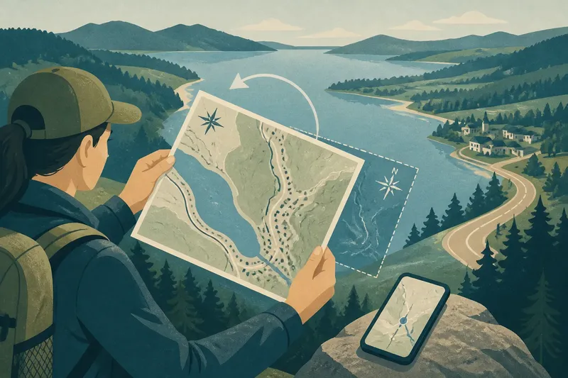
North-up map orientation puts north at the top of the page, but that familiar position is a convention, not a feature of the landscape. It makes maps easier to compare, while a rotated view can make a road, shoreline, or mountain chain easier to recognize from where you stand.
That distinction matters when you want to understand a region rather than simply locate a point. A map is a little like a window: its frame stays put, but changing your viewing position can bring a different pattern into focus.
North-up map orientation makes maps easier to compare
North is commonly placed at the top because a shared orientation gives readers a consistent reference. Directions such as “north of town” then correspond to the same part of the page across maps.
The convention also works well with map grids and many navigation tools. But north did not have to become the default: a map with east, south, or another direction at the top can still represent the same places accurately.
North does not have to sit at the top
North-up is a convention, not a rule of geography. A mapmaker may rotate a map to fit a long route on the page, emphasize a landscape, or show a place from a useful viewpoint.
Before interpreting an unfamiliar map, find its north arrow or compass rose. If neither appears, check the grid labels, legend, title, and any stated viewpoint; do not assume the top edge means north.
North-up maps can hide the direction of approach
A north-up map may show a harbor shoreline clearly while making its entrance appear sideways to someone arriving by boat. Roads that follow a coast, ridge, or valley can also look less intuitive when the page does not match the direction from which people encounter them.
Orientation can affect which places seem central, too. A map centered on one city may push nearby communities to the margins, even if their daily routes lead toward another regional center. Turning the page does not change those relationships, but it can make a different pattern easier to notice.
Turn the map to match a route or landmark
When a map is hard to match with the view outside, rotate it until a major route or landmark points the same way it does from your position. Then compare the sequence of junctions, towns, bends, or shoreline features—not just the shape of the whole region.
Say you are beside a long lake, facing a road that runs along its eastern shore. The lake lies to your left, but the north-up paper map shows it on the other side of the road; turning the sheet until the road points the way it does in front of you should make the shoreline and nearby junctions easier to match. Check the north arrow after turning so you do not confuse the page’s top edge with north.
A phone map may rotate with your movement, which can help you match the screen to the road ahead. A fixed north-up view is often easier for comparing places or following a region-wide route. The useful choice depends on whether you need a view that matches your heading or one that keeps direction consistent.
Choose an orientation that fits the task
- If you are comparing several places, check whether each map has north at the top; if they do, compare their positions directly, and if they do not, identify north on each before comparing.
- If you are matching a road or trail to the scene, check whether the route on the page points the same way as the route ahead; if it does not, rotate the map or use a heading-up display, and if it does, keep the orientation steady.
- If you are explaining directions to someone using a north-up map, check whether your map is also north-up; if it is, describe locations with cardinal directions, and if it is not, identify north before giving directions.
- If the map has a north arrow or compass rose, check where it points after rotating the page; if it is visible, use it to recover cardinal directions, and if it is missing, consult the grid or map legend before relying on direction.
- If a phone display seems to swing as you move, check whether its compass setting rotates the map with your heading; if it does, switch to a fixed view when you need a stable overview, and if it does not, use the route and landmarks to match the screen to the scene.
- If a regional map makes one town appear central, check the route network and neighboring settlements; if the routes converge elsewhere, compare the region from that other center, and if they do not, keep the current center while noting the map’s chosen viewpoint.
How do you read an unfamiliar map orientation?
How can I tell which way is north?
Look for a north arrow, compass rose, or labeled grid. If none appears, check the legend, title, and stated viewpoint, and avoid using the page’s top edge as a compass until you have a clear reference.
Why is a map rotated on the page?
A rotated layout can give a long route more room, fit a region onto a page, or present a feature from a chosen viewpoint. Use the north arrow to see how that layout differs from north-up.
Is a rotating phone map more accurate?
Rotation changes the display, not the locations represented. A heading-up view can be easier to match to the road ahead, while north-up offers a steadier frame for comparing places.
Can I compare maps with different orientations?
Yes. Identify north and any stated viewpoint on each map, then compare named landmarks, shorelines, junctions, or grid references instead of judging by where features sit near the page edges.
Orientation reveals different regional patterns
For regional geography, treat orientation as a lens and ask which relationship the map makes easiest to see. North-up often clarifies broad directional relationships; a rotated map may make a route, coastline, or chain of settlements easier to follow.
Compare the same place in a road atlas, a trail map, and a phone display. Notice where each route begins, which landmarks stand out, and whether the map’s top edge corresponds to north or to a chosen viewpoint. North-up map orientation provides a useful common reference, but checking the viewpoint can reveal how routes and settlements relate to the landscape.
When a map feels awkward, check its orientation before deciding the landscape itself is confusing. A small turn can help you match the page to the place without losing track of north.